A journal of canoe expeditions along the rivers of Australia's Murray Darling Basin using photographs, stories and information to highlight the beauty, challenges and history of these rivers and the communities they flow through.
Molesworth to Killingworth (57 - 76 km from Eildon).
Molesworth Caravan Park.
The Molesworth township is set about 500m back from the river flats. All the old river towns did this as a protection from flooding. Today many councils allow building much closer to the water: a recipe for trouble. Molesworth has been affected several times by flooding of the Goulburn River. Various bridges were damaged or washed away, and severe floods occurred in 1870 and 1934. (ref)
Outdoor dunny... having survived the floods of 1934, it is now a garden shed... The construction of the Eildon Dam reduced the risk of floods, and the connection of the town to the State Electricity grid brought electric refrigerators in pace of kerosene units. (ref)
Molesworth was named at the same time as Yea (1855) by a Government surveyor, probably after Lieutenant J. Molesworth, a casualty in the Crimean War about five months before. Molesworth had been a colleague of the Victorian Surveyor-General, Andrew Clarke, in the 7th Royal Fusiliers (see also the naming of Yea). An alternative version is that it was named after Sir William Molesworth, (1810-1855) Chairman of the Transportation Committee which recommended abolition of the transportation of convicts to New South Wales.
The first settler at Molesworth, John Sloan, built an inn and operated a punt across the Goulburn River for travellers to and from the Upper Goulburn goldfields. Moleswoth's beginning is generally calculated form Sloan's settlement in 1859. The township was surveyed in 1864 and a store with a post office was there by 1875. The primary school was opened in 1880. The railway was extended from Yea to Molesworth in 1889, at about the time a sawmill and a butcher were added to the township. Ten years later the Anglican church was opened. (ref)
Watching the sunset from the pub with a $10 parmi... there could be worse things.
Letting out your inner freak... at the New Year's Eve party.
Waking up with the gentle light before sunrise, I decided to have a look around Molesworth. From the caravan park, town was a 300m walk up to the higher ground to the South of the river. As with many small country towns, the caravan park was larger both in populace and size than the town itself. Set either side of the Goulburn Valley Highway, Molesworth appeared both functional and liveable. The town hall still sported the last piece of Christmas decorations, in the form of tinsel strung above its entrance door, the corner store advertised locally made sheepskin products and the pub used placards to let people know about its $10 parmies and an up and coming Eagles revival night. In places like these, the pub functions like a community centre and the bar staff, informal councillors.
Molesworth grew and identified with the railway which linked the town with its neighbours from the early 1889 till 1979. The construction of this line involved the building of a 220 metre tunnel. The Goulburn River High Country Rail Trail follows this track. Riders pass through the brick lined tunnel under McLoughlin's Gap between Cheviot and Molesworth. Although built during the Goulburn gold rush, it busiest times were between 1900's to the 1930's transporting timber to saw mills. From 1940 road replaced rail as preferred method of transport. Up until its closure in 1979 the railway supported local farms; there were even exhibition trains on good farming practise. Once the rail closed, other key services followed, with the primary school closing the next year. The rail trail, caravan park and pub now lead the way in a tourism based revival for the town. They all benefit from a healthy and beautiful Goulburn River. (ref 1, 2, 3).
By 8 am we were packed and on the water. We had seen the dark shape of the river moving silently and swiftly pass us during the evening. On a journey such as this, where we are riding a river through the landscape, getting off feels like losing ground. Goulburn Murray Water estimate that it takes 10 days for the water released from Eildon to reach the Murray River. Every hour that we spent off it meant more catching up the next day to truly follow that flow. As we allowed the current to catch the bows of our boats and point us downstream, it felt right, we were on our way again.
We followed the flow for 57 km (exactly the same distance as the day before), which brought us to a point 5 km downstream from Trawool. Feeling the heat from the day before, we slowed our pace a little. The river is impervious to human feelings and thoughts, it just is. It is a physical entity that follows the laws of nature, the predominant one being gravity. It continually searches for the quickest way down. Gravity is what powers the short cuts through the willows, eventually uprooting trees and forming the shallow fast streams that will eventually form the new river bed. In places the river visibly descends down drops which can be felt as you paddle over them. Occasionally these drops continue for kilometres, the speed of the current picks up and the water swirls and swells with current bubbles, small whirlpools and pressure waves. Teaming up with momentum, the faster current on the outside of the bends causes the river to bank like a kid running through the backyard pretending they can fly, scouring at the soil, collapsing the banks and bringing down mighty trees in the process.
The first ten kilometres after Molesworth has a montane feel to it. The river winds its way through tall mountain ash. we saw red headed gang gangs (a mountain member of the cockatoo family) and currawongs, both of which are associated with high altitude areas.
For the first 10 km after Molesworth, the river was flanked by tall and majestic mountain ash, with their distinctive ribbons of bark hanging from candle like trunks. Usually found at a much higher altitude, they give the Goulburn the feeling of being a mountain stream. Currawongs, gang gangs and bell birds (all mountain birds) added to the illusion that we were indeed much more isolated than we actually were.
Mountain ash only occur in cool areas of very high rainfall. This is usually the mountains, but Molesworth's climate seems to fit the bill. Source of graphic: Wikipedia
As the river raced around its bends it brought down some of these giants. Snags replace the rocky river bed of yesterday, the banks become sandier and the river changes from its dark translucent brown colour to the clear green that could be found in the middle sections of the Murray before carp and population pressure changed it. The banks become steeper, with up to two metres of sediment in places. Occasionally the hills which define the valley that the river flows through, run dramatically, straight into the river. In these places, native vegetation has been able to hold its own against the willows and one gets a glimpse at what the landscape would have looked like before Europeans arrived, with tea tree and melaleuca bushes reaching right down to the water's edge.
Killingworth to Ghin Ghin (76 - 83 km from Eildon).
At Killingworth, we passed by the pumping station for the North South Pipeline. It is almost undetectable from the water's edge. There is no large pipe to be seen; it is all deep underwater. Only a rock wall, warning signs about a submerged object and the house-like pumping station betray its presence: remarkably little fanfare for such a controversial piece of engineering.
The North South Pipeline during its construction in March 2010. In an article from that time, opposition parties said that the pipeline was taking water from already stressed river systems. (ABC TV)
This pipeline takes water released from Eildon which can then be pumped into Melbourne’s water supply catchment should that cities water reserves fail. Melbourne's can store around 1,810 GL in its reserves. In 2008, just before the last drought broke, the cities reserves reached a worrying low level (600 GL). The government embarked on two ambitious projects: the first was this pipeline and the second was a desalination plant. Both were politically contentious because of their cost and because of the environmental and social effects of the projects. Realistically, the government had no other short term alternatives. Wastewater recycling was decided on as the long term strategy of choice, but in the short term there was no other choice: Victoria would struggle to cope with the millions of environmental refugees should Melbourne run out of water.
Salt water worms swum upstream and colonised freshwater turtle shells in the 2000 drought http://www.australiangeographic.com.au/topics/science-environment/2009/07/gallery-working-on-the-murray-river
The Sugarloaf Pipeline effectively ‘drought-proofs’ the city by linking it to the largest store of freshwater in Victoria (Eildon dam holds 3,334 GL when full). The problem was, that the low levels in Melbourne's water reserves also existed in the rivers of the Murray Darling Basin. Salinity was so high in the Coorong that it 3 times saltier than the sea. In Goolwa, the Australian Geographic photographed school kids chipping away salt water tube worms from freshwater turtles shells so that they could swim. In the Lower Murray, acid sulfate soils poisoned waterholes and threatened to do the same with water flowing downstream. Steve Posselt (Cry me a river) left the Goulburn here and walked overland to Melbourne to highlight the plight of Australia’s inland rivers in 2008. I accompanied him as he paddled upstream from Echuca to the Goulburn junction. The Goulburn river was so low the year when he paddled up it that he often had to walk, or pull his way through tangles of snags.
Steve Posselt's Classic Trek in 2009 to highlight the plight of inland rivers. In 2009 Steve paddled up the Goulburn to Killingworth and then pulled his boat overland till Melbourne. Kayak4earth.com Watch on Youtube.
Lunch break in the shade of some obliging willows.
We saw many flocks of sulfur crested cockatoos today. Enjoying the tall trees either side of the river, their sentries would sound alarm as soon as we came into sight and sent the whole group in drive and drabs chaotically screeching and weaving through the bush. We saw few of the birds of prey, common along the drier stretches of Australia's inland rivers and no kangaroos. Near the end of the day we did see one rock wallaby. It puzzled us as to why there should be so few. Platypus appear to do well in the cold mountain water of the Goulburn. They surfaced just in front of our boats, quickly diving once they realised that they were not alone. There would be many more that we did not see.
2 km North of the Ghin Ghin bridge is the former township and goldfield of Ghin Ghin. Alluvial gold can still be found here. During the gold rush, there was active mining at Red Line Reef, City of Melbourne Reef (1, 2 &3), Providence Reef and McLeish’s Reef. More info on the mines and gold mining in Victoria can be found at Mines Victoria’s website (link).
The inhabitants of Ghin Ghin complain bitterly that notwithstanding the large population of the district, and the large amount they contribute to the general revenue in the shape of publicans' and business licences, etc, they have, nevertheless, no police protection. A memorial on the subject was some time ago forwarded to the proper authorities; the only reply received was to the effect that the place was not of sufficient importance to warrant the stationing of a constable at Ghin Ghin, but that one of those worthy functionaries would be occasionally sent to visit the place. We fully appreciate the moral effect of the presence of one of those dignitaries of the law; but we very much question whether a fortnightly visit will have sufficient influence in preventing drunken brawls and breaking of heads, which occasionally take place in the midst of such a large population as there is assembled at Ghin Ghin. Alexandra Times1868 (Trove).
Elaborate houses overlooking the Goulburn became more common as we approached Seymour.
Downstream of the Ghin Ghin Bridge, the river becomes shallower and wider. Willows dominate the shoreline once again and colonise the shallows leading to the development of treed islands and a mess of indistinct channels. River management authorities, blame willows for exacerbating the damage caused to the river banks during flooding. Able to grow and establish in quite strong currents, they essentially block the river, forcing it to go around them, creating a maze of channels which widens the river bed. Canoeing down the river, it is sometimes difficult to pick where the main channel is and impossible to be sure whether the passage will be safe. 5 km down from Ghin Ghin Bridge we had to ask local fishermen which was the best way to go. If there is no-one to ask, the channel with the most current (or the widest channel) is usually the safest.
Trawool to camp 5 km after the bridge reserve (107 - 114 km).
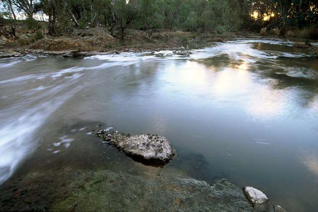
Approaching Trawool, there are some deep slow reaches where large rounded boulders line and dot the river. They are a stark contrast to what we have seen so far and quite photogenic. I can imagine that they would look beautiful in the soft morning light, or a winter fog.
The boulders.
Trawool has the Grand Old Hotel, a resort. The town is set about 250 m back from the river. It sports beautiful views over the Goulburn’s still young and narrow valley. Much of the land appears to have been cleared for cattle and sheep grazing. Access to Trawool is poor, consisting of a steep boat ramp underneath the Goulburn Valley Highway bridge. The only camping opportunity I saw was next to this boat ramp, but it would have been very noisy. We considered walking up to the resort to take a look, but with access so poor and no safe place to leave the boats, we decided to push on.
Trawool Resort: http://www.trawoolresort.com.au/
Downstream from Trawool the landscape appears like a Streeton painting.
It was now late in the afternoon, clouds indicated that thunderstorms were building. We began to look for a place to stay in earnest. This is not always an easy thing given that, especially in these conditions, it is important to avoid tall trees and overhanging branches. We sighted a makeshift jetty and fisherman's shack with a clear area where we could set up our tent and pulled in. The idea being that if the thunderstorm became severe, we could shelter under the hut's verandah. All of which we did, with the permission of the owners (John and Jo Stocker: now wine-growers, but formerly head of the CSIRO and advisor to John Howard on matters of scientific policy) who turned up a few minutes after we had arrived. Read more about this impressive man's contribution to Australian Science here. It was a great finish to the day, watching the rain fall, sitting on deck chairs under the protection of its old verandah, the river flowing gently by and the bush stretching into the surrounding hills.
What to do when a thunderstorm approaches when canoeing.
Keep up to date with weather forecasts, either online, or using an AM radio. Plan ahead for a safe exit.
Learn how to read the weather: tall cumulonimbus clouds are signs of a building storm. Alter your plans to allow for a safe exit.
If you can see lightening, or hear thunder, then it is time to seek shelter.
The best shelters are solid buildings with electrical cabling, or cars (because they are earthed).
Avoid tall trees, clear areas and tall poles. Seek low bushy trees of even height.
If there is no shelter, crouch on the ground on top of your lifejacket (it is an insulator) and protect your head.
If caught on the water, secure your paddle and lie down forwards on your boat.
For more information: 1, 2, 3, 4, 5,6, 7, 8, 9, 10
We sighted a makeshift jetty and fisherman's shack with a clear area where we could set up our tent and pulled in.
Thanks to John and Jo Stocker for permission to shelter at their idyllic hut. We had no idea at the time the important role this modest man had and still played in the development of Science in Australia - including the invention of Wireless LAN read about it here.
John and Jo Stocker, established a vineyard in 1987 on the sunny foothills of the Tallarook Ranges, after having developed an interest in viticulture in Switzerland. They named it 'Brave Goose' after a goose who protected the vines from marauding cockatoos and survived numerous fox attacks. The winery is managed by their daughter, Nina and her husband John. Brave Goose Winery. Facebook.
Brave Goose Winery patrons.
Relaxing on the veranda, sheltered from the rain.
After the storm had passed, the air was so humid and still that it formed a metre thick layer of cloud above the river at about the height of the bank. Tim thought he might sleep on the veranda, but the mossies soon convinced him otherwise and he joined me in the tent, where we spent the first half of the night staying as still as we could, savouring each and every breath of air which might venture into the tent to cool us down.
The Goulburn is not much of a river when it enters the Murray - most of the time. I live and grew up in Echuca, 18 kilometres downstream from the confluence of these two rivers. I have often visited the junction, as we call it, and rarely does the river push far into the Murray. Rather than speed up the river, paddlers know it as the place that the Murray slows down, as from this point on it comes under the influence of the Torrumbarry weir 80 kilometres further downstream. Occasionally however, it is a different story: when the Goulburn is in flood, it reaches the top of its 8 metre banks and, it's bed no longer able to contain it, it flows into the Murray through the forest in three different places. It has been known to cause the Murray to flow backwards as far upstream as the Barmah Lakes and even without a contribution from the Murray and the Campaspe, to cause widespread flooding in Echuca. When high volumes of water are moving down these rivers simultaneously, the effect can be catastrophic for the communities downstream.
The Goulburn obviously had power and a majesty all her own. Equally clear was that, living down the bottom end of that valley, I did not get to see it. This is where the idea to paddle the Goulburn came from.
The Broken River, a tributary to the Goulburn. In the 460km from Eildon to Echuca the river changes from a fast flowing mountain stream to a meandering river, making it very interesting to canoe down. Picture Source
In October 1824, Hume and Hovell left NSW to explore land between Cumberland and Westernport. Their party of eight included six convicts, two carts, horses and donkeys. On December 4th they crossed the Goulburn River at what is now Molesworth, seeking a passage from Sydney to Spencer
Gulf. Hovell recorded that there was “an abundance of fine grass and both hills and lowlands are thinly covered with timber. It is our opinion that we have not seen a more agreeable and interesting country since leaving home”. They camped on the banks of the Goulburn for two days at Christmas, s ‘in order that they might avail themselves of the fine fish which abound in its waters, as well as refresh the cattle.’ Hume and Hovell named the river after the then Colonial Secretary of NSW, Sir Frederick Goulburn. It paid to honour your sponsors even then. Of course it had many names before this. The Wurundjeri tribe and Taungurung language speakers are the traditional owners of the land, known as Murrindindi (ref 1, 2). Near Alexandra it was known as Koriella, lower down the valley, near Nagambie, it was known as Bayunga ref: http://home.vicnet.net.au/~goulburnriverclans/
Map showing the route Hume and Hovell took in their 1824 expedition, during which they were the first European settlers to record a crossing of the Goulburn River. Image source
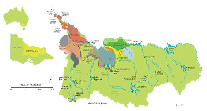
The Goulburn Valley is home to 215,000 people. It is used to irrigate 270,000 ha of private land and over 880,000 ha of public land. It has 70% of Victoria's fresh water storage reserves, around 50% of Victoria's underground water supplies and Australia's largest irrigation delivery network (more info). Channels supply water to land around Benalla, Shepparton, Kyabram and Nagambie, within the valley and via the Waranga Basin, further afield to towns along the Campaspe and Loddon as well as the growing cities of Ballarat and Bendigo. A controversial pipeline even throws a lifeline to Melbourne, should that 4 million metropol run dangerously low on water again as it did in 2009. The Goulburn is even used to supply cities such as Adelaide with a good flow, when not enough water is able to come down the Murray for that purpose without flooding low lying communities such as Picnic Point in the Barmah Forest.
Map showing how water from the Goulburn is shared between valleys and cities in Victoria. Map Source; Goulburn Murray Water
Given all these demands and the regulation that helps the river meet them, the river is surprisingly in good ecological condition. It is full of snags, which keeps larger boats and the problems caused by their wash away. Vegetation growth along the banks is strong minimising the effect of erosion by cattle and providing habitat for wildlife. After Shepparton, there is almost 200 kilometres of river redgum forest - now a national park. It was declared a heritage river in 1992. It is no wonder fishermen love it.
Eildon - Thornton (0 - 14 km)
Our journey began in Eildon, where my son Tim and I put into the water just below pondage number two at just after 11 am. The pondages are designed to increase the temperature of the water to cause less disruption to native fish breeding than would be so if the freezing water from the bottom of lake Eildon was allowed to flow directly into the river below. Whilst I have no doubt that this has some effect, it was still pretty damn fresh when we got it.
At the boat ramp immediately downstream of the Eildon pondage.
The current in the Upper Goulburn is strong, running at around 6km/hr.
'Bus stop' 3 km from Eildon.
We entered the Goulburn after 20 or 30 members of a white water kayak race, feeling a little out of place with our almost 6 metre long sea kayaks. Three kilometres later we met them again, still at the rapids they had finished at. Some cheered as we picked our way between the rocks and pressure waves that followed them. I had been nervous about how the boats would handle this section, but needn't have worried, even fully loaded, they kept their line well and were more than capable of handling the waves.
Site of the rapids at Bluegums Caravan Park, where the downriver race finished, where OEG have a base camp and where gates are set up for whitewater training. Source: Google Earth.
'The Sump'. About 3km from Eildon.
Straight near Point Hill Reserve, about 5km from Eildon.
The water is clean and clear with visibility easily over a metre. It is interesting to watch the bottom of the river, with all its colours as you paddle over it. It is almost like canoeing over a coral reef in a glass bottomed boat.
Initially the river flows through a cultured landscape. It is surrounded by farms and many of the trees that line its banks are non-native. In this section, we saw very few signs of erosion or pollution. The water was very cold and clear. It was often quite deep; bends opened lazily into long straights.
One of the first things Tim and I noticed was how clear the water was. We could easily see a metre through the water. It appeared crystal clear. We could see the full outline of our boats hulls as they glid through the water. Our paddles seemed shorter and leaves being tossed by the current deep in the river took on a life of their own as they reflected alternately, their own colour and then the colour of the sky.
I was struck how clear the water was and how healthy the water plants were. They swayed noiselessly back and forth in the current beneath our hulls as we passed over them.
It is 442 km from the base of Lake Eildon to the junction of the Goulburn with the Murray River. Goulburn-Murray Water estimate that it takes water in the river 10 days to travel that distance on average. We aimed to match that, although as we don't travel 24/7, it meant that we would have to do some paddling as well to achieve the same. That's the tiring bit. We had our first break just after Gilmore's Bridge, 18 km from where we had put in. It was a lovely flat area with a low bank which we could run the boats up onto and had plenty of shade to have a rest in as well. Officially there is no wild camping allowed between Eildon and Alexandra, but in an emergency, there are plenty of places to pull in.
Video grabs of what it is like to paddle on the river in this section.
The Upper Goulburn experienced a gold rush after the discovery at Jamison in 1854. In 1886, the 'Yea Chronicle' reported that the first crush of quartz and Prosser's Reef (just a few kilometres upstream from Thornton) had been most promising. Gold dust can still be found in streams by people panning for gold. More info: 1.
Thornton beach 2017. (Source: Google Earth Map of area). Image: TerryBickerton
Thornton Bridge
The first town we passed through was Thornton; like Eildon, a small place, so small that they share a football team, the 'shinboners', or 'boners' for short. Despite three premierships in 2000, 2001 and 2003, the club went into recess because of lack of players, but has now reformed and has great hopes for the future. Thornton is halfway between Eildon and Alexandra. Just before passing under Thortnon bridge (which takes you onto the Eildon back road), the Goulburn Valley Fly Fishing Centre (GVFFC) complex appears on the left, where they teach the art of fly fishing, run drift boat tours and offer accommodation. Thornton caravan park is set on the left bank of the river, just after passing the fly fishing centre and before you get to the bridge. The caravan park and the 'beach' are probably the best places to pull out if you would like to go into town for a look around.
A flyfishing drift boat. We saw a guide in one of these expertly negotiating the eddies below the 'sump' rapids at Blue Gums. They call it streamcraft... and yes, they teach that too at the GVFFC (image source: visitmelbourne
Thornton to the Alexandra (14 - 34 km from Eildon).
A great spot for a lunch break. We ran our kayaks up on the shore and were able to step onto dry land.
Goulburn Valley Highway (Gilmore's Bridge) 18 km from Eildon.
We were to pass under it twice today, once just after Thornton and then a second time just before Molesworth.
After 26 km, the Acheron a River enters from the South. Just before this, is one of the nicest situated caravan parks I have ever seen. It is called the 'Breakaway' and it was full of people who looked like they would prefer their patch of paradise remained a secret.
Breakaway Caravan Park is set right on the river under shady, safe trees. Ideal for canoeists and fishermen.
The breakaway gets its name because at this point, once the river reaches about 8,000 ML/d, flow starts going down the old course of the river, effectively turning the Goulburn into two rivers. There are remnants of levees in the mid-Goulburn. Indeed, levees on the riverbanks may have been the reason that the Goulburn has a breakaway near Alexandra. Two stories for the origin of the breakaway were heard — it was a neighbourly dispute with landholders on opposites sides of the riverbank building up the levees in competition until eventually one side blew and the breakaway formed with a new river course. Another version is that the breakaway started in 1912 following a big flood (the watercourse went through three properties, splitting them up). The breakaway was then further entrenched by feuding farmers raising levees on their own property to prevent flooding. http://www.mdba.gov.au/sites/default/files/Reach-reports/GRR-Loch-Garry-to-River-Murray.pdf
River heights can change rapidly on this stretch. Releases from Eildon are not always planned, but could be in reaction to heavy rain in the mountains above the dam. In general, the river is highest in summer, due to the need for water for irrigation downstream, with releases of 8,000ML per day usual and up to 18,000ML per day in short term environmental flows designed to improve the condition of the river bed, banks and billabongs. These changes in flow usually are brought in gradually, however are good reason not to camp too close to the water level.
Sudden changes, or flash floods happen following heavy rains in the area, because of the unregulated rivers which enter the Goulburn on this stretch. The Rubicon River, Acheron River, Spring Creek, Home Creek and Yea River are all known as 'flashy' because of how fast they respond to rainfall in their catchment. It pays to keep your eyes and ears open.
Just before Alexandra, the river disappears in a maze of willows. We took the left channel, which ended up only being a metre wide. Going off this 2012 aerial shot by Google Maps, it would have been better to try the right channel.
Maroondah Highway bridge near Alexandra. When preparing for your trip, or driving in, bridges give you an opportunity to check water level and flow. It is one thing to look up levels on a website, but nothing beats seeing them firsthand.
Alexandra to Molesworth (34 - 57 km from Eildon).
An afternoon break in the shade at Brooke's Reserve Canoe Camp, 2 km downstream from Alexandra.
The river bed is usually between 25 and 40 metres wide in this section, around 2 metres deep and with a current of around 6 km/hr. As it snakes through the landscape it bounces from one set of hills across the plains to another and then repeats. Each valley crossing involves many turns and often takes 8 or 10 km because of these. Sometimes the river runs right into one of its giant neighbours and turns dramatically.
At times the river runs dramatically right into the hills that define its valley, bouncing off them as if they were a mirror, or running alongside in a silent challenge.
In many places willows cover the banks. Sometimes these grow so thickly that there is only 5 metres of river left to paddle on. If they manage to take a toe hold on a gravel race in the middle of the river as well as on the sides, then watch out. This happened at around 34 km into the trip. Rounding the bend it was not at all clear where the river went to. In truth, most just went straight through the willows which acted as strainers all the way across the river. Slowly edging our way along the bank, (because it is easier to pull out there if you are in trouble than in the middle), we noticed a metre wide gap. Once through, the river opened up again. When stones or trees channel the current into a narrow shoot, its speed increases dramatically. On one occasion, we were able to push our speed up to 18 km/hr, however or average was 9.8.
Sky and riverbanks reflected in the still water.
An old and collapsing private bridge, with grass growing on it, about 5 km before Molesworth.
Our initial aim was to overnight at Brooke's Reserve Canoe Camp 2 km downstream from Alexandra, however as we arrived at around 3pm, we decided to push on, eventually arriving at Molesworth at around 6:30 pm, having paddled 57 km for the day.
Passing under the Goulburn Valley Highway bridge at Molesworth. There are actually two bridges; the first is an old rail bridge which is now used for the Goulburn River High Country Rail Trail (walk / cycle / ride) which follows the river off and on, from Mansfield, through to Tallarook.
The water remained clear all day. We saw three platypuses, a sacred kingfisher, black swans (which appeared to be protecting a nest), black ducks, moor hens, several murders of crows, crimson rosellas and raucous small groups of cockatoos.
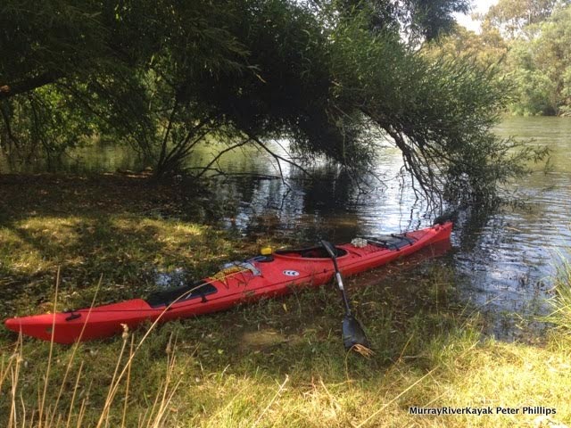
Our camping spot at Molesworth, about 150m from their boat ramp. Having a kayak trolley meant that we didn't have to unpack to move the boats, which saved time and energy, both of which we were short of at the end of the day.
In camp, Tim and I enjoyed a good hot shower and a well flavoured trangia meal - the secret ingredient being a curry sauce. I was glad we had that, as I had also experimented with tinned ham - which unfortunately looked and had the consistency of dog food.


