Goulburn River Paddle Day 5: Old Toolamba - Maneroo Rd bush camp.


Goulburn River Paddle
Day 5: Old Toolamba - Maneroo Rd bush camp
238 - 298  (60 km)


Click on the red pins for information on a feature from today's leg of the journey.

It had rained all night, but despite heavy falls in other areas, the rain where I camped had only been gentle, steady and soaking. My tent was well and truly wet, but it had done its job and kept me and everything else inside of it dry. Whilst price is usually a good indicator of quality, this little Aldi tent has been fantastic. It has kept me dry on all my journeys and although it is starting to look a little worse for wear, I have a difficult time parting with it. It has become like an old friend, a place of comfort and security to retire to after long days on the river. Like my boat, my tent has become an extension of self, it is a cocoon to recover in, a safe place to unpack and spread out all the gear that I have worked so hard to keep dry, and in the evening, a protective bubble to keep out the ever present mosquitoes.

My trusty green tent: cheap, but well designed and constructed.

Waking around sunrise after a pretty broken night, I wished I could have another two hours sleep. The thought of a whole day paddling in the rain may not have helped either. I decided to look on the bright side; canoeing in the rain is very peaceful, (there is no one else on the river - why, I wonder), and when the rain eases there can be a gentle mist rising. I also told myself that it wouldn't be as hot as the last few days. I put on my only fleece jumper and my gortex jacket. It was going to be cold and I was tired, however, there was nothing to it; I had agreed to meet my fellow canoeist, Barry Bell of the Shepparton Canoe Club at a bend just after the Toolamba bridge at 8:30 am. This was 15 km away and I still had to get there yet.

I hit the water at 7:17 am, snacking on fruit, muesli bars and nuts as I went. My arms still wouldn't work. They were stiff and tired. I remembered a similar feeling the night I had accepted cheap red wine from supportive campers near Wentworth on the Murray. A penny for your thoughts, so to speak. On that occasion, I paddled bravely out of sight and then limped for the first 5 kilometres till everything had shaken off the short night and accepted the task ahead. It was no different this time. I arrived at the Toolamba bridge site at 8:45 am, a picture of fitness. It was just a pity that Barry was already on the water and ready to go, as I had used too much energy keen to make a good impression with that fast arrival!

Once underway, the night's stiffness slowly disappeared and I allowed myself to be absorbed by the beauty of paddling on a river patterned by raindrops. These are quiet times. Birds go silent in the rain, only to sing all the more loudly immediately following it, the sounds of their calls echoing off the wet foliage, as if in a rainforest.

 Beware of the crocodiles: one fisherman's way of keeping his favorite spot. 
Near Toolamba on the Mooroopna-Murchison Rd.

There are plenty of potential beach campsites in this stretch of the river.

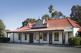
Toolamba Rail Bridge 1.5km South of Toolamba. In the foreground is one of the original brick pylons, with the concrete supports of the 1963 Goulburn Valley Railway in the background. The Goulburn Valley Railway connects Shepparton with the Sydney to Melbourne Railway at Seymour. At Toolamba, a branch line heads via Kyabram towards Echuca. It was reopened in 2011 (article) providing an alternative route for rail freight from Denilquin (especially the annual rive crop) to reach the Port of Melbourne. Up until that point rail freight from these areas could only travel at night as it disrupted passenger services between Bendigo and Melbourne.
 https://www.wyndhamere.com.au/attractions

Toolamba Bridge. Source: visitvictoria.com One story I read about this bridge was told by a farmer who had property either side of the bridge in the 1970's. They used to drive their herd of milking cows across it. They said that it was an old bridge, even back then. Toolamba has a population of around 900 people. It has a general store, a kindergarten and primary school, the Junction Hotel and a Bed and Breakfast (wikipedia).
 https://publocation.com.au/pubs/junction-hotel-toolamba


Barry Bell from the Shepparton Canoe Club kept me company for the 24km into his home town. Barry was the only person to paddle with me, and almost the only canoeist I met on the entire 470 km journey.

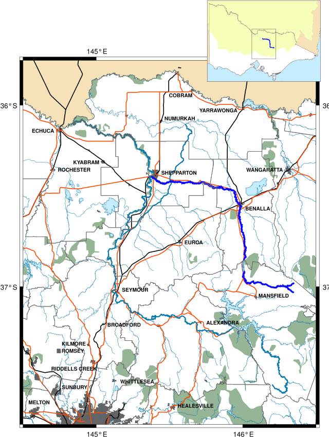
The junction of the Broken and Goulburn Rivers. The Broken River originates on the slopes of Mt. Buffalo passing through Benalla, it meets the Goulburn at Shepparton. It is called the Broken River because, before regulation, it was more often a series of waterholes than a river (ref). The Broken creek which diverges off the Broken River shortly after Benalla is the original path of the river. It flows through Numurkah and Nathalia before reaching the Murray upstream of Barmah.


Broken River: Source Wikipedia. When the Broken River is in flood it is said to be the fastest river on the plains of the Murray Darling Basin.


Flood Map for Shepparton when both the Goulburn and Broken Rivers are in flood. The blue area indicates areas inundated by water at 12.3 m on the Shepparton Gauge. The Broken River and Seven Creeks join the Goulburn River south of Mooroopna and Shepparton and make the area very prone to floods. Flooding in the area has affected people, property, businesses and livestock since 1870. The Goulburn River catchment collects rainfall from the Seymour area, the Great Dividing Range and water releases from Lake Eildon. The Broken River and Seven Creeks catchments collect rainfall from the Benalla, Euroa and Strathbogie areas. Floods in these areas often result in floods in Mooroopna and Shepparton. Mooroopna and Shepparton are also at risk of flash flooding after heavy rain because the land is so flat. Source: Local Flood Guide for Shepparton and Mooroopna.  

ABC News report from the 2010 floods in Shepparton.

Wet, but toasty warm from the work out it took to keep up with Barry. No danger of a flood today. Although the rain was steady, it was not heavy. All the same it pays to have a working radio tuned into local news to be sure that you know what is happening upstream on the tributaries which contribute to the river you are paddling on. This is especially important when making camp.
"Your looking good, let's go" said Barry. Barry was on an OC1, a racing boat. Having seen the speed I arrived at he continued at a similar pace, which he described as leisurely. Keeping up with Barry was a challenge, which is all the more impressive if you consider that he is also between 15 and 20 years my senior. Luckily Barry allowed me to slow down a bit and have the odd break. All the same, the 25 km we paddled together was close to the fastest I had paddled on the trip.

After the Mooroopna Railway Bridge, the first obvious sign of Mooroopna is the industrial landscape of the SPC Ardmona fruit company. SPC stands for Shepparton Preserving Company. It's fortunes have long been a bellwether for those of the region. Locals identify so strongly with the company that threatened funding cut backs in Feb 2014, became a national political issue with the sitting liberal member Sharman Stone, standing up to her own party and eventually winning (smh article).

On the right hand bend, just before the Kialla Road Bridge is the site of the original Punt Crossing on the Goulburn River (1875 – 1877). When the river is low enough, you can also see the remains of the Mooroopna Wharf and the barge C1877. Kialla Bridge which was built in 1877, originally had a drawbridge in the centre to allow steamers to reach the wharf. Barry showed me the 'shoot' on the left side of the river as you go under the bridge. It is the fastest patch of current in the local area. He described how local paddlers like to see how fast they can go there. Keen to give it a go with Barry, I saw his boat disappear into the distance.

On leaving Mooroopna, the Goulburn snakes for 5 km through a native flora and flora reserve known to locals as 'The Flats''. As with most of the nature reserves along the rivers of the Murray Darling Basin, the Flats are floodplains. It does not pay to build anything permanent there. The open space and rich environment did attract members of the Yorta Yorts aboriginal community who walked off Cummeragunga Station in 1939 in protest over conditions. They stayed on the Goulburn, which they called Kaiela, until the 1970's.  A September 1946 police report listed 130 people aged from 8 days to 80 years living on the ‘flats’ with a third of them less than 15 years of age. Lodgings consisted of 29 dwellings, 22 being assortments of tin or hessian bag huts and the rest tents. The river provided abundant food including crayfish, red fin, yellow belly, cod as well as possum, turtle, turtle eggs, swan, duck, crane and other birds and their eggs. The women predominantly fished whilst the men would hunt for rabbits.  Every year the river would flood, causing the residents to move to higher ground on Daish’s paddock, now home to KidsTown Adventure Playground (mmg article).


During the Queen’s visit of 1954, when hessian bags were placed along the causeway to prevent Her Majesty from seeing the humpies and tents. ‘‘Everyone was waiting for the Queen to come through so she could see,’’ Mr Turner said. ‘‘People thought they might get some help out of it — but it wasn’t so. ‘‘The hessian sacks stayed there for weeks.’’ (mmg article).
Source: Goulburn: Talking Fish: Making connections with the rivers of the Murray Darling Basin
It was nice to have company and with Barry as guide, I saw a side of Shepparton that I had not seen before, like the 6km walk from the pool and gym at the lake, which takes you over the Goulburn River on a suspension bridge and to the Giants kids playground in Mooroopna; the 6 km of riverside walk and the rock wall rapids downstream of the Goulburn Valley Highway road bridge.

The Goulburn River upstream of Shepparton flows through state park. It's banks are covered in beautiful native tussock grasses. In the rain, the gold colour of the mature seed head carrying stalks and the green of the young shoots becomes more vibrant and I cannot help but admire them. This is what Australia Felix must have looked to Mitchell when he first ventured into the interior in 1836 and told tales of rich and promising pastures. There is a movement back to using native grasses for pasture. Apparently they are richer in nutrients than non native grasses and are preferred by sheep and cattle. Being deep rooted, they are more drought resistant and can also recover from bush fire. They do not cope with being trampled, or over grazed. Those farmers who have successfully experimented with natural pastures say that in order to manage them effectively, less stock can be put on the land than with introduced grasses. I hope that more take up the use of these impressive grasses. The land, cattle and wildlife would benefit from such a move. (Native pastures info DPI, ABC, Landcare ).

River Red Gum; Image source: Jess Gibbs


Greater Shepparton Council (biodiveristy statement)


Shepparton is a town which reflects much of what Australia dreams of being. It has always been home to migrants and it seeks prosperity through agriculture. In Shepparton's case this was not on the sheep's back but through dairy and fruit. Both have struggled with structural reform of farming in Australia and recurrent persistent drought. It is constantly seeking to reinvent itself - expressed though this creative Stegosaurus cow at the town's information centre. Source
The birds that seem to enjoy the rain most were the kingfishers. I have never seen so many on one stretch of river. Sacred kingfishers with their white bellies sit higher above the water than their Azure cousins, but both enjoy fishing. Sacred kingfishers fly to redgum forests in the south of Australia all the way from New Guinea and the Solomon Islands to breed in the tree hollows. The azure kingfishers are smaller and look as if they have no tail. With their reddish bellies and white streak behind the ears, they definitely look like they are wagging school. When seen, the usually fly low over the water, ducking under logs and flying through snags, till they land on another good place to fish undisturbed (please). Sorry little kingfishers.

Sacred Kingfisher  (Todiramphus sanctus) Source: Arkive


The diet of the sacred kingfisher is quite varied, and includes a wide range of insects and other invertebrates, such as spiders, centipedes, worms and crustaceans. It also preys on small vertebrates, including fish, tadpoles and frogs, lizards, snakes, birds and mice. Sacred kingfishers can be quite territorial, often calling and aggressively chasing away intruders, including other bird species... it is thought that breeding pairs return to the same breeding and non-breeding territories year after year. The breeding is between September and January or March, with the exact timing depending on the location. Sacred kingfishers usually nest in a tree hollow or in a tunnel excavated in a bank, cliff or even a termite mound. Source: Arkive


Azure Kingfisher: Ceyx azureus. With its combination of royal-blue plumage on its upperparts contrasting with orange on its underparts, the Azure Kingfisher is one of the smallest and most dazzling kingfishers in Australia. This diminutive species inhabits the vegetation beside waterways and other wetlands, where it often perches on low, overhanging branches, searching for its prey of fish, crustaceans and aquatic insects, captured by shallow plunging into the water. Anglers on lonely rivers are sometimes surprised to find an Azure Kingfisher perched quietly on their fishing rods instead of a branch. Source (picture and text: Birdlife Australia).


Downstream of Shepparton, litter pollution is an issue, both in the water and on the land at the frequented camping spots. It is better to seek a lesser used spot as there will usually be less rubbish. A canoe or kayak traveller, needs little more than a flat spot of ground to set up tent and there are plenty of these. The rubbish catches on snags in the river, like the special booms that are in city rivers. I would rather see the bottles, balls, tv's and inflatable toys in these than in the snags on the river. Perhaps it would be a good idea to install these. Lobby your local council. Protect the bush.

In this article by Environment Victoria, local paddler, Dianne Brown describes the joys and frustrations of paddling in the Goulburn around Shepparton. Whereas she saw balls and firehoses, I saw pool toys and television sets. Do they really all come from storm water? Do some people use and leave their flotation aids? Do people really throw their old televisions into the river and why? Shepparton's floating TV's accompanied me all the way to Echuca. Being a resident of that town, I had always wondered where they came from. It is not something that I have seen anywhere else in all my journeys in the Murray Darling Basin.

About 4 km downstream from Shepparton road bridge is a rock wall which is passable at high river but otherwise a portage is necessary. Another 2 km further is an even larger wall. Portaging here is made easier by a boat ramp just upstream and downstream of the wall. I managed to get through both, but make sure you check out the levels and know what you are doing before you try that. Err on the side of caution.

Shepparton Weir. The water was high enough to paddle through without touching the bottom. Another portage saved.

Video footage of passing through the Shepparton Weir.

Shepparton Town Weir at low water level, showing the step like construction which allows fish to move through it. Source


Beginning in Shepparton, the Lower Goulburn National Park protects most of the land either side of the river until it's confluence with the Murray River 160 km away. Many people say this is the most beautiful part of the river, due to its isolation and ecological integrity. I am looking forward to paddling through this area, a place I grew up in, but know so little about.

Lower Goulburn National Park Notes 

The Goulburn River is lined with River Red Gum (Eucalyptus camaldulensis) and is an important wildlife corridor linking the mountains of the Great Dividing Range to the Murray River. The river is highly scenic with its narrow strips of riparian vegetation along its meandering banks. The adjoining River Red Gum forests and woodlands provide a striking contrast to the adjacent farmland. The Victorian Government created the Lower Goulburn National Park, along with other new and expanded parks, in June 2010 to protect and enhance the River Red Gum forests in Victoria.

River Red Gum forests have high natural, cultural and economic values. These forests are coming under increasing pressure from climate change, drought and reduced water flows in the northern rivers. Protecting this precious environment relies on balancing economic and recreational activities with preserving its natural beauty and values. River Red Gums line the Goulburn River for most of its length. These iconic trees have been known to reach 45 metres and live for more than 500 years. The trees need periods of flooding and can survive inundation for months. Their seeds are washed onto higher ground during a flood and germinate and grow before the next flood reaches them. Hollows and broken branches provide nesting for galahs, cockatoos, cockatiels and various parrots, while fallen branches provide habitat for other animals.

The River Red Gum forests and Yellow and Grey Box woodlands between Shepparton and the Murray River are notable in terms of size, lack of disturbance, diversity and botanical ‘intactness’. The River Red Gum forest with areas of grassy and shrubby understory, plus the large number of wetlands, billabongs provides habitat for a number of significant fauna species including Brush-tailed Phascogales, Barking Owls, Royal Spoonbills and Musk Ducks. Areas containing tree hollows and mature Silver Wattle contain habitat of national significance for the rare Squirrel Glider. Flora species of note include the endangered Grey Billy-buttons, Small Scurf-peas and Jericho Wiregrass. Reedy Swamp, north of Shepparton, when filled, is a haven for waterbirds including the Glossy Ibis and the Royal Spoonbill.

Unlike many Victorian rivers, the Goulburn River below Shepparton remains largely undisturbed. Instream debris and large snags provide valuable habitat for Murray Cod and other fish species.


Whilst it faces the challenges that all inland rivers in Australia face, there are some success stories really worth celebrating in the Goulburn River. I barely saw a carp before Shepparton and very few before the junction with the Murray near Echuca. Credit goes to the catchment management authorities, but also to farmers, fishermen and naturalists. One of the most interesting accounts of change, how the river used to be, and what we can aim for again is from 'True tales of trout cod'. This remarkable research uses the stories and photographs of old fishermen. It forms a valuable resource and provides an insight into the both the past and the processes that happen on the river. When we better understand the impact of our actions on the river, we can, in most cases modify our behaviour so that the health of the river improves.


Fishermen's tales


I pulled in early today. 8 hours of rain soaked paddling and a short night have sapped my energy. It has also meant that I was able to start my blog early, download the photos from my GoPro and hopefully upload them before evening. There are also devices to be charged. There was not enough sun today to charge my lithium battery, so I am using a sealed lead acid battery to do that job. With phone and cameras charged, blog written, wet clothes hanging between the layers of the tent to dry. It's time for a cold beer to celebrate the day!


Goulburn River Paddle Day 4 Lake Nagambie - Old Toolamba.


Goulburn River Paddle
Day 4 Lake Nagambie - Old Toolamba.

I began my paddle on Lake Nagambie before most people were awake. The water was still smooth as glass. There was almost a perfect reflection of the sky and the surrounding bush on the water. Lake Nagambie is a flooded landscape, there are islands of vegetation, each its own biosphere, which dot the shallow areas of the lake. Each small island is a refuge for all manner of land plants, growing on stumps of the forest that was here before the Goulburn Weir was built in 1893. I saw red gum saplings, bottlebrush, blackberries, grasses and understory shrubs growing on the stumps. They look like the unkempt hair on a teenage boy as they sprouted from their toe-holds into the overwhelming space of the lake. This is great kayaking country - so long as you get up early or come in at time of year where there is not too much boat traffic. In the quiet of the morning I saw black swans, spoonbills, rainbow bee-eaters, apostle birds, tree martins, the sacred Kingfisher and heard cockatoos singing the only way they know how, trying to clear the neighbourhood of all the competition. Turtles splashed into the safety of deep water as I approached. I am constantly amazed at how alert they are when they seem to be sleeping and how well they see, when their eyes are so small.

Packed and ready to go. Only a few people in the caravan park were awake. Chinaman's bridge caravan park.

One of the nice things about this caravan park was that it was easy to put my boat in and out of the water. Chinaman's bridge caravan park.
Looking onto Lake Nagambie from my launching spot, the water is still smooth, and peaceful.
Nagambie Waterways Land and On-Water Management Plan 2012 
Nagambie Streetscape. Tourism Victoria. The Nagambie community has a passionate interest in the management of the Nagambie Waterways with regard to economic, social and environmental issues associated with the waterways and their surrounds. 
Nagambie history: Nagambie's story is linked with that of the explorer Thomas Mitchell. Overlanders followed the route he took, using the rivers as a guide and source of feed on their journey from Sydney to Melbourne, They forded the Goulburn at Mitchellton and stayed at John Clarke's Inn, the first establishment of its kind (1938) outside of Melbourne in Victoria. The land on which Nagambie would develop was taken up as a squatting run in 1845 by Hugh Glass and John Purcell. Chateau Tahbilk was established in 1860 on a part of this run with the help of French vigneron Ludovic Marie. A hotel, church and blacksmith were set up to cater to the through-traffic of teamsters journeying along the river system. Glass had the township surveyed in 1868 by Marie. Land sales proceeded in 1870 and it was proclaimed as the private town of 'Nagambie' in 1872, said to be derived from a local Aboriginal word meaning 'lagoon' (Sydney Morning Herald). The first paddlesteamer arrived from Echuca in 1875, followed shortly afterwards by the railway in 1881. in 2013 the Hume highway was diverted around Nagambie, removing the through traffic, but also much of the business associated with it. Nagambie now focuses on its beautiful location rather than the people passing through it.


The peaceful atmosphere which I was paddling in this morning must be what Lake Nagambie looks like most of the year, when it is not full of speedboats and jet skis.

Black swans (Arkive.org) are common in Nagambie Lakes, with shallow backwaters providing shelter and plenty of water plants to feed on. A group of swans is called a bank. When they fly in formation they are called a wedge. Black swans can be nomadic. They mate for life. Both partners are involved in looking after the nest and bringing up the young. The scientific name 'Cygnus atratus' means 'a swan attired in black'. European explorers took examples back to Europe; some have managed to escape and establish wild colonies in England. The first birds taken to Europe were under the orders of Napoleon for his wife, Josephine. She was extremely fond of these birds because of their exotic nature and red beaks. Red spots were seen as a sign of beauty in France at the time, with ladies often sporting them on their cheeks. On the journey back to Europe, the swans were fed red wine and bread. Somehow they managed to survive (The rise and fall of Josephine Bonaparta: Kate Williamson ABC Radio National Late Night Live).

Islands of vegetation growing on tree stumps which have been underwater since 1893.
Sunlight through the redgums on the banks of lake Nagambie.
The stumps make it easy to follow the original course of the Goulburn through the lakes. On the map this is not at all clear. Away from the channel, there are shallow areas called backwaters stretching into the distance. The realm of fishermen, but inviting exploration from canoeists. This morning it is the realm of pelicans, swans, moorhens and the yellow water hyacinths, an impressive lilly, a mixture of other garden escapees such as irises, native bulrushes and other wetland vegetation. After Kirwan's bridge the lake narrows and the fishing shacks and holiday homes are are replaced by wheat and sheep farms - a glimpse back in time. The boating zone changes to open water, meaning that waterskiing is permitted. With the number of wake boats and jet skis, this can be cause for concern, however this time the stumps act as protection, providing safe space for canoeists to travel in. Kirwan's Bridge is as interesting to pass under as it is to drive over, the weathered skeletal remains of its original redgum frame have been kept, like decorations, around the more recent structural improvements.

Yellow Water Lily (Aquaplant.tamu.edu)  increasingly a problem in waterways of the Murray Darling Basin. A native of Mexico, Yellow waterlily is increasing an alarming rate in Lake Nagambie and in channels and dams which feed from it, including the billabongs and waterways of the Gunbower Perricoota Koondrook Forest. Once established it can block waterways and is difficult to eradicate. New growth of this plant is mainly initiated vegetatively. Stolons are produced during spring to autumn specially following flooding. Stolons produce new plants at the nodes. (Emerging aquatic weeds in Victoria). All parts of the plant must be removed in order to remove it, or the lake drained and exposed to frost (as was done to lake Mulwala in 2013).

Most banks are covered by trees, but in some places, erosion is faster than the growth of the vegetation which otherwise might protect it. Perhaps an ancient sandhill?


Fishing on Lake Nagambie (Coxy's Big Break).


Old bridge remains linking narrow points of land between the Eastern and Western Backwaters on Lake Nagambie.

Kirwan's Bridge
Kirwan's bridge was closed for some time and a boulder placed at each end to stop traffic driving across it, however there was such an outcry from local and tourists, that funds were found for its repair and maintenance. It was reopened in 2011.  ABC News Report on the re-opening of the bridge.
So significant was the access to Nagambie it provided for those living on the west of the Goulburn River that a threat to the bridge’s continuing future in the mid-1950s led to a municipal secession movement that enlarged the Shire of Goulburn at the expense of Kirwans’ original builders, the Shire of Waranga. The current narrowed timber deck with passing bays, supported by rolled steel joists placed over the ancient piers, remains a memorial to that municipal protest. It is one of Victoria’s very oldest timber road bridges still in operation; very few are earlier. Kirwans Bridge is also one of a unique group of four large timber road bridges from the 1890s, of contrasting types, located on the Goulburn River between Seymour and Murchison; this is the last remaining group of large old timber river bridges in Victoria. The 310 metres long Kirwans Bridge is situated over the Goulburn River at Bailieston near Nagambie. It was opened in 1890 and is still in use for one-way motor traffic. The only comparable timber bridge in Victoria in terms of length is the 1927 Barwon Heads Bridge which is 308 metres long. The bridge features a dramatic mid-stream bend and is also unique in its incorporation of two vehicle passing-bays. Source: Victoria for everyone
Celebrating a wedding with photos on Kirwans Bridge. CombiLove
Kirwans Bridge: old and new supports. 
Fishing Shacks

Boathouse
The size of trees growing on submerged stumps is limited by the amount of nutrients that can collect in the small amount of room their roots have to grow in: I imagine that birds sitting in their branches would be the main source of these. Grasses and mosses trap and build soil slowly, protecting sensitive roots from the harsh summer sun. Lack of water, would, I assume, not be a problem.
In the early morning and evening light, the lake is serene.

Water mirrors sky, a timeless scene. The Goulburn River Valley once supported a population of hundreds of members of the Taungurung (Daung wurrung) Aboriginal people. The country of the Taungurung includes the area between the upper reaches of the Goulburn River and its tributaries north of the Dividing Range; from Kilmore in the west to Mount Beauty in the east, and Benalla in the north and to the top of the Great Dividing Range in the south. Evidence of the Taungurung can be found in many places throughout Taungurung Country, and includes scar trees, rock shelters, rock art and place names. For instance, Nagambie or ‘nogamby’ means lagoon. (GMW). I think that the river in its quieter moments, would be a place where they could find peace.
Most trees from the pre-existing river bed are only stumps, yet this one survived over 100 years of inundation. The snags, stumps and trees all provide habitat for waterbirds and turtles.


 There are extensive areas of shallow water around Lake Nagambie and the old river course, as well as underwater objects such as logs and standing trees. Such areas provide valuable fish habitat, however, they can also obstruct boating and present safety hazards (GMW). Without much of a current, these are difficult to see, so care needs to be taken when navigating these areas.
At the weir Ruth and I met Paul, one of the Goulburn Murray Water officers. He answered our phone call to their Nagambie office and let us through the locked gate at the back of the compound. The number is not the same as the a number on the sign out the front of the building. When we tried to call for the duty officer, Telstra informed us that the number no longer existed. It turns out that the phone system was changed a few years ago and since the automatic diversion of calls worked for the first year, no-one bothered to change the sign. The correct number is (03) 5794 5900, but in case it changes again, check their web page (http://www.g-mwater.com.au/).

Meeting up with Ruth, I had to push through a bank of reeds.

Looking back into the lake from the boat ramp just in front of the weir.

The path from the boat ramp just before the Goulburn weir: closed to motor boats, but an easy exit point for canoes and kayaks. The track leads straight to the weir car park, where there are very good toilets and plenty of shade and green grass to relax on. To portage around the weir, call Goulburn Murray Water  (03) 5794 5900  a couple of days ahead and arrange for the locked gate to be opened and (if you need it) transport for your boat to the ramp below the weir. If you throw your boat over the fence and crawl under, especially in front of their noses (the Nagambie office overlooks the weir), prepare to be yelled at. The gates are locked because of a recent drowning: a tourist was caught in a stopper wave at the base of the weir. We were advised that it is best to call ahead a couple of days beforehand, so that a staff member will be present (they travel all around the district inspecting irrigation infrastructure) and be keeping an eye out for you.  

Lazy acres: a simple home, but a fisherman's paradise. Just above the Goulburn Weir.

It must have been a long time ago that the road continued on straight ahead. This sign seems to be stating the obvious, but at night it could well be a life saver.

Sign at the Goulburn Weir showing the water resources managed by Goulburn Murray Water. Not only does the authority manage all of the water resources in the Goulburn Valley, but also all of the dams and rivers on the Victorian side of the Murray. They manage the Hume Dam jointly with NSW water authorities. All up the area managed by the authority is equivalent in size to the state of Tasmania.
The weir wall is open to the public weekdays from 8am to 4pm. If possible, take the time to do walk over the weir to see the segment of original wall at the far end of the weir. The original electricity generation house and electrically mechanism for the gates are still on top of the wall. You will also see how much water is diverted away from the natural river and into the channels, lifeblood for farms, towns and cities further and wide.
Paul said that Goulburn Murray Water prefer canoeists to call them and arrange for a transfer around the weir (they will open the gates and offered to take my kayak on the back of their ute) which only takes five minutes, to half an hour of yelling at them for trespassing. He said that about a month ago a fella was seen throwing his canoe over the two meter fence and then climbing after it. It's much better to call ahead, or at least to knock on the weir office door, both for the boat and for the feelings of the workers at Goulburn Murray Water. Paul suggested that in order to arrange for this service, it is best to call a couple of days ahead to arrange a time - just make sure it is a week day as the office is not manned on weekends. If you do this, they'll be there to help you and the portage will be a much more pleasant experience.

The original cast iron gates, stone base and generator house from 1891 on the Goulburn weir. Some of the gates which were dismantled when the weir was upgraded in 1987 have been transported to and reconstructed at the Australian National Museum in Canberra. GMW General Manager Catchment Services Graeme Hannan, said that two of the original piers, one gate and one section of a walkway have been donated to the Museum (GMW).


Water released as part of an environmental flow into the Lower Goulburn. Plan your trip to coincide with summer irrigation and environmental flows (call GMW to check when these are planned) and you will have more current and less trouble with snags. 

Looking back to Lake Nagambie from the section of original weir wall. The cogs and whells are part of the still functioning original weir gate control mechanism.

The gates which block the way to the base of the weir since a drowning some years ago. Call Goulburn Murray Water Nagambie office on (03) 5794 5900  and arrange for assistance weekdays between 8am and 4pm.

"The Goulburn Weir has seen over 1-million visitors and even appeared on the Australian half sovereign and 10 shilling bank note. (GMW).

When the Goulburn Weir was built in 1891, it was the largest water engineering project in Victoria. It was built with sandstone hewn from nearby hills: as you walk over the weir (open weekdays 8am - 4pm) you can see them at the base of the wall. Unlike weirs on the Murray River, which were initially built to improve navigation for river trade by paddle steamers, the Goulburn Weir was built as a water reserve for irrigation. This scheme so excited people of the time, that it was featured on a bank note of the time. No expense was spared with its design. A hydroelectric generator was installed to operate the gates using electricity and lights installed to show off the spillway and weir structure. Special trains were chartered for people to picnic in its grounds and to admire the electric lights at night. Country sports days were held at the weir for many years and on Armistice day, the flags of all the allied nations were flown there. It was a symbol of national pride.

Two channels (Cattanach and Stuart Murray) take water from Lake Nagambie to the Waranga Basin and one channel takes water to the Shepparton Irrigation Area. Nagambie Waterways Land and On-Water Management Plan 2012.
The Stuart Murray Channel and Goulburn River at the Goulburn Weir. The Cattanach channel leaves Lake Nagambie 400m further upstream. Nagambie Waterways Land and On-Water Management Plan 2012.


On the left you can see how much water is diverted from the river into the Catternach canal.
Comparison of water levels above and below the Goulburn weir (Lake Nagambie compared to the Lower Goulburn River).

Three channels leave the weir, providing water for irrigation throughout the lower Goulburn Valley for fruit orchards and dairy production and town water supplies, and, via inter valley channels and the Waranga Basin, contributing to development and water security in the Loddon and Campaspe River systems as well the cities of Bendigo and Ballarat. Usually, only a quarter of the flow from the upper Goulburn is allowed to flow down its original river course, the rest is diverted via channels. Given how seasonal and unreliable our rainfall is in Australia, it would not be possible to grow enough food for our population, let alone export, without such schemes and the visionaries that created them. They do contribute to problems in the Murray Darling Basin, such as salinity caused by over-irrigating, the deteriorating condition of redgum forests, wetlands and the soil in seasonal floodplains by decreasing the frequency and size of floods in those areas. The lack of flow in rivers within the Murray Darling Basin caused the Murray mouth to be blocked for many years and water in the Coorong to be much saltier than the sea. Water birds dependent on these wetlands to feed their young and fuel their global migration began to die out and water quality and security in the lower catchment towns (including the Capital city of South Australia: Adelaide) began to suffer. Community concerns and international obligations to the preservation of wildlife forced the Australian government to act, bringing the three state governments together to agree how to better manage their shared water reserves: and so the Murray Darling Basin Plan was born. The arrogant and ignorant attitude of 'If it flows past my door I can use it and what happens downstream is no concern of mine' was no longer allowed. Catchment Management Authorities now cooperate to ensure that the environment is not forgotten and that water is managed following strategies that benefit the whole basin. On my paddle, this meant that I had an environmental flow, more water than usual was being released, promoting native fish breeding and delivering water downstream at the same time. It also improved the current, making my journey easier.

Source: Kingsford et al.42 
Waterbird abundance during annual aerial surveys of waterbirds across eastern Australia, 1983–2010

The graph shows changes relative to the long-term mean (dashed line). Some of the long-term changes are related to effects of river regulation, reducing the frequency and extent of flooding on large wetlands systems. For example, wetland extent over this period peaked in 1984, associated with the peak in waterbird numbers. Dept of the Environment: Ecological processes and species populations report 2011.

In the company of a Goulburn Murray Water staff member, we were able to drive down to the boat ramp below the weir. Although you can see three gates open here, in winter, often only one will be.

Walking down to the water. The launch area was protected from the current with plenty of space to get in.

Every portage means unpacking and repacking. Finally ready to go again.
The weir dog knows all :).
Pushing off.
On my way again... but on a dramatically different river.

With normal, rather than dammed levels, beaches appear once again.


Downstream of the Goulburn Weir, the river changes remarkably, the banks are covered in native grasses and the bush looks healthy. All of the vegetation is native; there is no sign of the willows so dominant above the weir. A large male eastern grey kangaroo watched me as I paddled past. The surface of the water was so covered by the ripples left by moving water skaters looking for their insect prey, that it looked like it was raining. The sound of water cascading from the weir behind me ebbs and wanes. Sometimes it is quite loud and I caught myself having to check behind, unable to be sure there really was not a great wave about to engulf me.

The lower Goulburn is the section of the river below Goulburn Weir at Nagambie. The river slows and the banks grow higher. Its colour changes to the green brown of many of Australia's inland rivers. It is no longer the mountain stream that it was above Seymour. It is a though the Goulburn has grown up. Map source: Wikipedia. See also DEPI for information on river conditions.

This section of the Goulburn River is lined with River Red Gums and is an important wildlife corridor linking the mountains of the Great Dividing Range to the Murray River. The picturesque river has narrow strips of vegetation along its meandering banks, with the adjoining River Red Gum forests and woodlands providing a striking contrast to the farmland which was so often a feature along the upper Goulburn. See Park Web


 A few kilometres below the weir I came across this remarkable brick water tower, which I believe belongs to a local winery.


The reason why the current is much slower in the Lower Goulburn than in its upper stretches is because the rate of fall is much less: the Goulburn drops most dramatically (300 m) in the first 200 km: in its last 250 km, it only drops around 50 m. Reach report
Remains of an old private wharf or landing upstream of Murchison.

The no longer used Murchison Railway bridge, just upstream of the town.
Murchison railway bridge runs through Campbells Bend Picnic Reserve. Murchisonvictoria.com.au
Murchison road bridge (Goulburn Valley Highway). Approach carefully. I found it virtually blocked by snags. I took the left channel, but had to break my way through. The right channel would have been easier. 
There is an elaborate set of steps down to the river from the town, right after the bridge. They were blocked by a tangle of snags when I passed through. They are the only access to town, 12 metres or so above the Goulburn river's summer level. Murchisonvictoria.com.au
Murchison is the first town you pass through after the weir. There is a set of steps leading down into the river by which you can access the town. They were surrounded by snags when I passed through, so landing there is possible, but would be a little tricky. Snags also almost totally blocked the old railway bridge, just upstream of Murchison. The best place to go through is on the right hand side as you going downstream, take another route and you'll experience difficulty. I did, I had to crash through some snags and duck low under a large log. There are many sandbars in the river bends at and following Murchison, which are popular with local fishermen and their families during holiday periods. There are so many though, that finding a campsite is not difficult. As it was a humid day, many people were standing, or sitting with their chairs in the cooling river water. We chatted as i paddled past.

The Goulburn River looking down from the top of the bank in Murchison. Murchisonvictoria.com.au


There are many camping sites around Murchison. It was Friday afternoon as I passed through and the weather was hot. Everyone who could be was down at the river. Some had come down to swim, others had set up for the weekend and had just thrown in their first lines, hoping to be able to catch something for the evening meal. I have seldom seen so many good camping sites so close together. i later heard that people come from a long way away to camp here.


I continued on, hoping to make it to Toolamba, but with thunder signalling the threat of an approaching storm, my radio informing me of heavy downpours in the region and tiredness from a long day on the water, I pulled in for the night 4 km upstream from Old Toolamba, at a beach campsite. Tomorrow I will pass through Mooropna and Shepparton and will be accompanied by Barry Bell, a fellow paddler and friend, who drove along the bush tracks and shared a beer with me last night.
My campsite for the night. A spot safe from overhanging trees and where I could easily pull out my boat. The following shots are panoramas of my campsite.


With thunderstorms rolling in, I ate by my boat. It was quicker than taking all the gear up and down and with the wind building, less to blow away. Ruth had brought down a beer for every day I had left - a luxury I have never had before. I was determined to enjoy this one: storm, or no storm!

Location of my campsite, not far from Toolamba.